Good gracious. This is an odd-looking building. Where is it and why is it unusual? Send your best guess of what it is as well as something about it. Send to editor@charlestoncurrents.com. And don’t forget to include your name and the town in which you live.
Our previous Mystery Photo
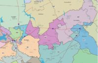
Our Aug. 17 photo, “Spaghetti roadways,” is more familiar than many readers probably realize. It’s a drone view of the road coming off the Arthur Ravenel Bridge in Mount Pleasant.
Among those who identified the photo by Davin Martin via Unsplash were: Jamie George of Johns Island; Chris Brooks, Kirk Zerangue and David Lupo, all of Mount Pleasant; Claire Gibbons and Delia Smith, both of Charleston’ Randy Herald of Lexington; Allan Peel of San Antonio, Texas; Marnie Huger of Richmon, Va.; George Graf of Palmyra, Va.; Wayne Beam of North Myrtle Beach; and Charles Davis of Aiken.
George outlined how the aerial view of the Ravenel Bridge in Mount Pleasant was a much more complicate network than when the Grace bridge was the only game in town: “Starting at the center bottom of the picture, to the left is the parking lot for Waterfront Park with an obscured playground under the elevated lanes. The left four elevated lanes go west into Charleston.
“From the bottom center of the picture to the right are apartment homes, and office buildings; and the four elevated lanes here go east into Mount Pleasant, two on to Highway 17 and two to Coleman Boulevard. The bicycle/pedestrian path is on the far right.
Further to the right is Patriots Point and the ball fields. The two center elevated lanes criss cross about two thirds of the way from the top.”
- Send us a mystery: If you have a photo that you believe will stump readers, send it along (but make sure to tell us what it is because it may stump us too!) Send it along to editor@charlestoncurrents.com.

 We Can Do Better, South Carolina!