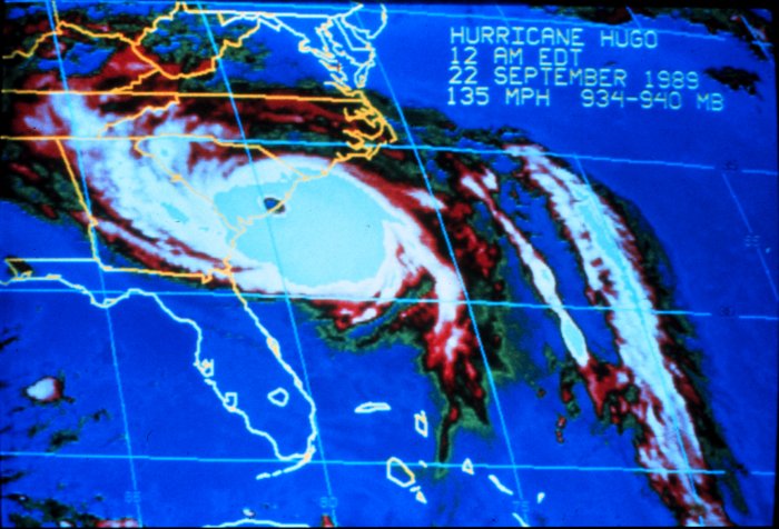
S.C. Encyclopedia | The term “hurricane” comes from the West Indian word “huracan,” which means “big wind” and is used to describe severe tropical cyclones in the Atlantic Ocean, Gulf of Mexico, Caribbean Sea, and the eastern Pacific Ocean. In the western Pacific, hurricanes are known as typhoons. The development of a hurricane requires an area of low pressure in a region of favorable atmospheric and oceanic conditions. Ocean temperatures must be near or greater than 80 ̊ F and wind speeds at mid- and upper-levels of the atmosphere must be light. At the center of the hurricane is the eye, a region of calm winds and subsiding air immediately surrounded by the most violent winds and precipitation called the eye wall. The counterclockwise rotation of cyclones in the Northern Hemisphere creates spiraling rainbands that span outward from the center. The outer rainbands of a hurricane, which can extend over an area three hundred to five hundred miles in width, contain the highest wind and heaviest precipitation away from the eyewall.
As the Northern Hemisphere summer approaches, more direct sunlight and longer daylight hours allow tropical oceans to warm sufficiently to support hurricane development. For that reason hurricane season runs from June 1 to November 30 each year in the Atlantic Ocean, Gulf of Mexico, and Caribbean Sea. During this time South Carolina is susceptible to land-falling tropical cyclones ranging in strength from tropical depressions (sustained winds less than 39 mph) to tropical storms (winds of 39 to 73 mph) and hurricanes (winds of 74 mph or higher).
Hurricanes are classified into five categories using the Saffir-Simpson scale based on maximum sustained winds, minimum central pressure, storm surge, and damage. Between 1900 and 2004, fifteen hurricanes hit South Carolina directly, making the average landfall once every seven years. Three of the fifteen hurricanes have reached major hurricane status of category 3, 4, or 5 on the Saffir-Simpson scale. The average for any tropical storm or hurricane landfall in South Carolina is once every four to five years. Storms that make landfall along the Gulf of Mexico, Georgia, and North Carolina coastline often impact South Carolina as well. The primary threats from hurricanes in South Carolina include storm surge, high winds, rainfall-induced flooding, and tornadoes.
The storm surge develops as high winds pile up water ahead of hurricanes and low pressure near the center causes the sea level to rise. On September 22, 1989, Hurricane Hugo made landfall near Sullivan’s Island with a storm surge of twenty feet in Bulls Bay. Storm surge reports of ten to fourteen feet were reported along the entire coastline from Folly Beach to Myrtle Beach. The maximum sustained winds just before landfall in Hugo were estimated at 140 mph. The damage from Hugo was catastrophic with an estimated $10 billion damage from the Caribbean to the U.S. mainland. In South Carolina hurricane force winds were reported inland as far north as York County. Shaw Air Force Base in Sumter experienced winds of 66 mph with gusts to 108 mph. Thousands of acres in the Francis Marion and Sumter National Forest were destroyed.
Thirty years earlier Hurricane Gracie hit Beaufort on September 29, 1959, with 125 mph winds and gusts to 150 mph. The storm surge associated with Gracie was less severe than with Hugo since the hurricane made landfall within an hour of low tide. Rainfall amounts with Gracie totaled three to eight inches in South Carolina and flooding of streams and rivers occurred well inland along the Appalachian Mountains. The main threat from Hurricane Gracie was the high winds and potential for tornadoes. Damage in South Carolina reached an estimated $14 million, with more than half the amount in Charleston County alone. The preliminary report from the Hurricane Warning Center in Miami (now the National Hurricane Center) described the damage as “the worst from a hurricane in the history of Beaufort, South Carolina.” Ten deaths were attributed to the storm in South Carolina, primarily due to downed trees and power lines and automobile accidents.
With a forward speed of more than 30 mph and winds more than 130 mph, Hurricane Hazel moved inland near Little River at the border between North and South Carolina on October 15, 1954. Wind gusts were observed to reach 106 mph at Myrtle Beach where more than 170 miles of piers and beachfront property from the Grand Strand northward to near Wilmington, North Carolina, were destroyed. A seventeen-foot storm surge was responsible for $61 million in beach damages, with another $100 million reported inland due to flooding and high winds. Twenty people drowned due to rainfall-induced flooding across the Carolinas as ten to twelve inches of rain fell in the mountainous terrain.
Perhaps the most remarkable storm in South Carolina’s hurricane history occurred prior to 1900. Termed the “Great Storm of 1893,” the late-August hurricane made landfall along the southern coast with little or no warning. A tremendous storm surge and high winds were responsible for more than two thousand deaths.
In 2004 South Carolina experienced one of the busiest tropical seasons on record with six storms affecting the state throughout the summer. Hurricane Charley became the first direct landfall from a hurricane in fifteen years as the storm made landfall near Cape Romain as a category 1 storm.
South Carolina had not experienced a direct hurricane landfall since Hurricane Hugo in September 1989. Less than a month later, Hurricane Gaston, also a category 1 storm, moved inland over the same area. For only the second time since 1900, two hurricanes made landfall in South Carolina during a single Atlantic Basin hurricane season. The last time was in 1959 when Hurricane Cindy preceded the ravaging effects of Hurricane Gracie.
Since Hugo in 1989, the coastal population of South Carolina has increased by nearly 150,000 citizens and the tourist population during the summer months has increased significantly. Storm surge remains the leading potential killer in tropical cyclones along the coast, while inland rain-induced flooding with tropical storms is the most underrated killer with the most observed casualties. In 1999 Hurricane Floyd made landfall in North Carolina but generated floods of one-hundred-year and five-hundred-year proportions in northeastern South Carolina along the Pee Dee, Waccamaw, and Lumber Rivers.
— Excerpted from an entry by S.C. State Climatology Office. This entry hasn’t been updated since 2006. To read more about this or 2,000 other entries about South Carolina, check out The South Carolina Encyclopedia, published in 2006 by USC Press. (Information used by permission.)


 We Can Do Better, South Carolina!


